The St. Joe River and St. Maries: the highest navigable river, the log drives, and the fire that filled a cemetery
St. Maries, Idaho · View stopPublished researchRivers & waterTimberFireTrade & transport
The place
St. Maries is a working logging town on the St. Joe River in northern Idaho. The river made the town, and the river is famous: the U.S. Forest Service calls the lower St. Joe the highest navigable river in the world. River writers add an honest footnote — “by some definitions.”
A hundred years ago, paddle-wheel steamboats carried as many as 1,000 passengers up this river. The steamboats are gone. The work isn't: tugboats still tow rafts of logs past town, down to the mills.
What happened here
In August 1910, the fire everyone here just calls the 1910 fire tore through these mountains. Firefighters died across the region, and dozens of them were brought to St. Maries and buried together at Woodlawn Cemetery, west of town.
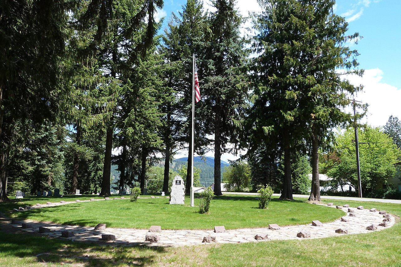
They lie in circles around a granite marker shaped like a flame, put up by the Forest Service, and the town has kept the memorial ever since. The books don't quite agree on the count — 54 to 59 men, depending on the source — so this page prints the range instead of pretending.
What you can see now
- Woodlawn Cemetery — the circles of firefighters' graves and the flame-shaped marker, west of town.
- The riverfront — tugs towing log rafts still pass. There's no schedule; stand on the bank a while and watch the river work.
- Logger's Memorial Park, downtown — a memorial naming more than 250 St. Joe loggers killed on the job.
- Hughes House Museum, at Sixth and Main — a historic log house that holds the town's logging history.
- The St. Joe River Scenic Byway — 47 miles upriver to Avery, through the country the log drives came down.
Before you go
- St. Maries has full services year-round. Local time is Pacific.
- Woodlawn Cemetery is public ground in daylight. It is a working cemetery — go on the paths, and visit like a guest.
- The byway is open to Avery all year. Past Avery the road isn't plowed and can be snowed shut, roughly November to May.
- Hughes House hours weren't verified for this page — check before you count on it being open.
The full record
Everything below is the complete research record for this place — the story in full, what stands there now, the gaps we print on purpose, and the sources. Read as much or as little as you want; the plain version above is enough to go.
St. Maries is a year-round, full-services town, and its two anchor stops are public ground: Woodlawn Cemetery (west of town; a working cemetery — visit as a guest, in daylight, on paths) and the riverfront itself, where tugs still work the lower St. Joe. The St. Joe River Scenic Byway runs year-round from St. Maries to Avery (47 miles); beyond Avery the road is not plowed and may be closed by snow roughly November–May — in late November, plan the trip as St. Maries plus, at most, the lower byway. Local time: Pacific.
Where you go
This entry's dossier names no visitable public anchor — no lawful public ground a reader can be sent to is established in its locator record. The entry is carried as research reading, with its sources below, and is flagged for the owner's ruling on whether it belongs in the Research Desk instead of the travel catalog. Nothing has been invented to fill the gap.
Before you go
- Woodlawn Cemetery / 1910 Fire Memorial, St. Maries: public cemetery west of town (Forest Service guide gives the route: west out of St. Maries). Concentric-circle graves, flame-form granite marker (Forest Service memorial erected 1924 per local history), steam donkey on site. Open cemetery access in daylight; conduct rules apply — this is a burial ground, not a photo set. No NRHP listing verified in this pass. [S3, S7]
- St. Joe River lower reach / St. Maries riverfront: public boat ramps including St. Maries Aqua Park; tug-and-brail traffic is working river traffic, viewable from shore and ramps — do not promise a sighting on a schedule. [S7, S1]
- Marble Creek interpretive country / Hobo Historical Trail #254: Forest Service trail (non-motorized) past a splash dam, steam donkey, and logging camp remnants; trailhead via Forest Highway 50 to Forest Road 321 at Marble Creek. The agency rates it easy with a steep return climb; conditions vary by season — a November visit requires a current check with the St. Joe Ranger District (222 S. 7th, St. Maries). [S4]
- Hughes House Museum, St. Maries: a historic log house at Sixth Street and Main Avenue, opened as a museum June 18, 1990 (Forest Service commemoration guide). The town's logging-history museum and the natural indoor anchor — but current hours unverified in this pass; a release gate, below. [S3]
- Logger's Memorial Park, downtown St. Maries: public park memorial naming 250+ St. Joe loggers killed on the job (local-history source; verify on site). [S7]
- St. Joe River Scenic Byway: St. Maries to Avery year-round; beyond Avery unplowed, snow closure roughly November–May. In winter the byway is a St. Maries day, not a through-route. [S8]
The story
The claim, examined
The St. Joe's famous superlative survives scrutiny only with its attribution attached. The U.S. Forest Service's own description, quoted in full by a river guide, reads: "Its lower reaches at an altitude of 2,128 feet make it the highest navigable river in the world. On this working river, tug boats pull rafts or 'brailes' of logs to lumber mills in St. Maries and Coeur d'Alene. The tugs are living history, operating where paddle-wheelers once did." That is the claim's strongest form: an agency statement about the lower river's altitude, where "navigable" means deep, placid water that carried steamboats and still carries commercial log tows. A Big Sky Journal river essay gives the mouth elevation as 2,129 feet, notes the river rises at nearly 6,500 feet in the Bitterroots, and adds the honest qualifier the app should keep: the St. Joe is "the world's highest 'navigable' river by some definitions." Nineteenth-century steamboats ferried as many as 1,000 passengers on the lower river; St. Joe City was the paddle-wheelers' last stop. Print the claim as the Forest Service's, with the qualifier — a superlative with its paperwork showing is worth more than a bare one. [S1, S2]
Even the river's length will not sit still: sources in this pass give 140 miles (Big Sky Journal), 132 miles (a river essay drawing on Wild & Scenic materials), and "over 120 miles" (Benewah County's own fact sheet). Print the range or pick the figure with its source named; do not average them into a false precision. [S2]
The drives
St. Maries grew where the St. Maries River meets the St. Joe — a steamboat stop and, in the local chamber's words, "a major distribution center for raw logs at the junction." Local history reported by a St. Maries realty history page (a secondary source; see gaps) dates the townsite to Joseph Fisher's sawmill choice, with the first mill up in 1889: "The rivers were the road: logs floated down to the mills and steamboats carried finished lumber out to market." The Milwaukee Road reached the St. Joe country in 1908–09, and the drives began their long retreat to the tributaries. [S7, S2]
The drive system itself was hydraulic engineering in the woods: steam donkeys, chutes, flumes, and splash dams that stored a creek's water and released it in a flush to carry logs down tributaries like Marble Creek to the St. Joe, where they floated to the mills. On Marble Creek, an interpretive sign at the Camp 7 splash dam — photographed in October 2026 — calls it "one of 15 built between 1915 and 1931 to flush logs down Marble Creek to the St. Joe River during spring drives"; the Forest Service's own trail page for the same creek's Hobo Historical Trail calls its splash dam "one of 5 on Marble Creek." Fifteen or five — the sign and the agency page disagree, possibly over what counts as a dam or which creek system is meant. Print both numbers with their sources; the disagreement is itself a finding (see Section 5). [S4]
The men who worked the drives left voices. The Camp 7 sign quotes Wash Applegate (1972) recalling that two men, Bill Delyea and Ben Marquette, drowned at the dam when the gates opened — Delyea's body recovered, Marquette's never found. Logger Axel Anderson, interviewed for the Latah County Oral History Collection, remembered the St. Maries River drives and their ending: logs were "dumped in the river… they had dams here and there… they drove millions of them there, but after the railroad come in, you know, then the drives, that all quit." Of Marble Creek he says the drives ended after the 1922 fire burned the flumes and the company "built the incline" instead. And Frank McPherson, in the Idaho Panhandle Oral History Project, remembered working drives in 1926 and 1927 — "The last drive was in '26. Started in '26, got 'em out in '27… The river was only 20 or 30 inches deep at times, had a hell of a time getting them out. Took them two years to get the logs down here." McPherson's drainage is not pinned in the excerpt read; quote him as a drive hand of the region, not as the St. Joe main stem's last-drive witness. No source in this pass establishes a single "last log drive" year for the St. Joe itself, and the lower river never entirely stopped moving logs — the tugs and brails the Forest Service describes are the drive's working descendant. [S4, S5, S6, S1]
August 20, 1910
The St. Joe country was, in Big Sky Journal's phrase, "ground zero" for the Big Burn. The Forest Service's Northern Region commemoration guide frames the event plainly: a 36-hour firestorm on August 20–21, 1910 burned nearly three million acres, and "although numbers vary, it is believed that 85 people died in the fire and most were Forest Service firefighters." Crews died at Big Creek and Setzer Creek in the St. Joe drainage; at Avery, upriver, Ranger Thaddeus Roe's account — published in the Seattle Daily Times of August 28, 1910 — describes losing his Setzer Creek crew and falling back on Avery, where firefighters, townspeople, and Buffalo Soldiers of the 25th Infantry (sent in August 17) lit the backfire that saved the town. Roe's number for his lost crew was twenty-four; the magazine presenting his account notes other references say twenty-seven. Both numbers stay in print. [S3, S9]
The dead came down to St. Maries. The Forest Service secured a plot in the city cemetery in 1912, and the Woodlawn Cemetery memorial is now the fire's largest single burial ground: graves arranged in concentric circles around a granite marker "chiseled to resemble a large flame," many of them unknown men. How many men lie there is a genuinely unsettled number in the sources: the Forest Service day-trip guide says the cemetery "is the final resting place for 58 men who perished fighting the 1910 fires"; a St. Maries local-history page says 54 firefighters killed that day were buried under a granite memorial the Forest Service erected in 1924, with remains of more men from Big Creek and Setzer Creek later moved there; Big Sky Journal says 59 were interred at St. Maries; a byway guide says 54. Print the range and the sources (Section 5) — a cemetery is the worst place in the world to round a number for neatness. A steam donkey stands at the site as part of the memorial landscape, tying the fire ground back to the logging world the dead men worked in. [S3, S7, S2]
St. Maries also keeps the longer ledger: Logger's Memorial Park downtown carries the names of more than 250 St. Joe loggers killed on the job — the fire's 54-to-59 are one night in a century of dangerous work, and the town remembers both scales. [S7]
Then / now
Then, the lower St. Joe was a working highway: paddle-wheelers to St. Joe City, splash-dam flushes on the creeks each spring, brails of logs moving down to the mills, a townsite chosen for a sawmill. Now, the upper river is a designated Wild and Scenic River, the creeks are quiet, and the lower river still works — tugs towing log rafts past St. Maries are, in the Forest Service's own words, "living history, operating where paddle-wheelers once did." The Marble Creek woods hold the drive era's remains in place: the Forest Service's Hobo Historical Trail passes a splash dam, a steam donkey with its cable, and a logging camp — archaeology you reach on foot, not behind glass. The 1910 fire's then/now is Woodlawn Cemetery itself: a 1912 Forest Service plot that is still the region's firefighting memorial, rededicated in 2010. [S1, S4, S3]
The stop, step by step
1. Hughes House Museum (if open — confirm first). The logging town's own museum in a log house at the town's center: steam donkeys, steamboats, and the St. Joe's working century in one room-sized dose before the river itself. If it is closed, the progression still stands — start at the riverfront. [S3]
2. The riverfront at St. Maries. Read the claim where it can be tested: the Forest Service's "highest navigable river in the world" is about this lower, placid reach at 2,128 feet. Watch for tug traffic without promising it; the point is that the highway is still in use. [S1, S7]
3. Marble Creek / Hobo Historical Trail (season and road permitting). Walk to the splash dam and steam donkey: the drive system at arm's length, with the Camp 7 sign's drowning account as the human price tag. Winter fallback: skip without apology — the trail's own agency page warns conditions vary, and a November entry that routes visitors up FR 321 unchecked would fail this dossier's standard. [S4]
4. Woodlawn Cemetery, last and unhurried. The concentric graves and the flame-shaped granite. Read the number problem aloud — 54, 58, 59 in the sources — because the uncertainty is part of the record of that night: many of these men were never identified at all. [S3]
Strongest story moment: at the memorial, the pairing of the two St. Maries ledgers: one August night in 1910 filled a circle of graves, and the town's Logger's Memorial names 250 more men the woods took one at a time. The St. Joe made St. Maries rich and kept billing it. No invented testimony is needed; Roe's published account and Applegate's quoted recollection are already in the record. [S3, S9, S4]
Where it was
The historic location as the record gives it — information, not an entrance and not directions. A historic pin is not a public entrance; the visitable anchor and the Before you go section govern where you may stand.
- Historical place
- St. Joe River (lower navigable reach and Marble Creek tributary) and St. Maries, Benewah County, Idaho
Locator record
- Stable name
- St. Joe River / St. Maries, Idaho
- Printed address
- — blank in the record
- Operator
- — blank in the record
- NRHP / National Register
- — blank in the record
- HMdb
- — blank in the record
- ARK
- — blank in the record
- Archive ID
- Latah County Oral History Collection (University of Idaho Library) — Axel Anderson interview; Idaho Panhandle Oral History Project (USFS) — Frank McPherson transcript. Collection names recorded as cited; no item-level ARK verified.
- Register URL
- — blank in the record
- Coordinates
- — blank in the record
- Coordinate source
- — blank in the record
- archives west ark
- — blank in the record
- official register listing
- — blank in the record
- governing cfr
- — blank in the record
- agency specification
- — blank in the record
- coordinate datum
- — blank in the record
- official manager
- City of St. Maries (Woodlawn Cemetery; Logger's Memorial Park); USDA Forest Service, Idaho Panhandle National Forests, St. Joe Ranger District (Marble Creek / Hobo Historical Trail)
- public interpretation sites
- Woodlawn Cemetery 1910 Fire Memorial (west of St. Maries); Hughes House Museum, Sixth Street and Main Avenue, St. Maries; Marble Creek / Hobo Historical Trail #254 via Forest Highway 50 and Forest Road 321
- Stable dossier ID
- HT-RES-ST-JOE-ST-MARIES
- Historical place
- St. Joe River (lower navigable reach and Marble Creek tributary) and St. Maries, Benewah County, Idaho
- Locator completeness
- LOW by design — no register number and no coordinates are asserted. The next research step is the Benewah County / Idaho SHPO record for the Hughes House and the memorial, and the Forest Service's own Marble Creek interpretive-site page, before any pin is published.
Blank fields are blank in the source dossier. Nothing is invented to fill them.
Honest gaps & disagreements
- "Highest navigable river in the world" — qualified, not verified as an absolute. It is the U.S. Forest Service's published characterization of the lower river at 2,128 feet; a second source gives the mouth at 2,129 feet, and the most careful popular treatment adds "by some definitions." No international registry or adjudicating body for the title was found. Public copy must carry the attribution and the qualifier. [S1, S2]
- The memorial count: 54 / 58 / 59. Forest Service day-trip guide: 58 men rest at Woodlawn. Local St. Maries history: 54 buried under the 1924 memorial, with additional remains from Big Creek and Setzer Creek later reinterred (which could raise a later count toward 58–59 without any source being "wrong" — but that reconciliation is a hypothesis, not a finding). Big Sky Journal: 59. Print the range with sources; never a single rounded figure. [S3, S7, S2]
- Setzer Creek deaths: 24 vs. 27. Roe's own published account says twenty-four of his firefighters; the presenting magazine notes other references say twenty-seven. (Wave 1's Avery research encountered a 28 figure as well.) Print Roe's number as Roe's, and the others as others'. [S9]
- Splash dams on Marble Creek: 15 vs. 5. The Camp 7 interpretive sign (photographed 2026) says one of 15 built 1915–1931; the Forest Service trail page says its dam is one of 5 on Marble Creek. Unresolved; possibly different counting scopes. Print both. [S4]
- River length: 140 vs. 132 vs. "over 120" miles. Print with sources or as a range. [S2]
- St. Maries founding details rest on a single secondary page (a realty firm's local-history summary) for the Fisher townsite and 1889 first mill, and the same page's county-formation chronology is demonstrably muddled. The townsite/mill claims are plausible and widely repeated but should be confirmed against Benewah County or Idaho State Historical Society material before publication.
- Hughes House Museum current hours unverified — the 1990 opening is documented by the Forest Service guide; no current operator page was read in this pass. Release gate for any itinerary that depends on it.
- No "last log drive" year for the St. Joe main stem is established. Oral histories date the ends of specific tributary drives (Marble Creek after the 1922 fire and the incline; McPherson's 1926–27 drive, drainage unpinned). Any source claiming a single last-drive year for the river itself needs to be produced before the claim is printed.
- No coordinates or register numbers adopted. No NRHP reference for the memorial or the Hughes House was verified in this pass, and no source read prints coordinates for the stops; locator fields stay blank.
Save & note
Checking your sign-in…
Records & sources
S1 — U.S. Forest Service St. Joe River description, as quoted in full in "One Fine Morning on the St. Joe" (Palouse Pics, 2018): https://palousepics.com/2018/03/13/%e2%80%8bone-fine-morning-on-the-st-joe/
S2 — Erickson, "Ode to the St. Joe River," Big Sky Journal (2020): https://bigskyjournal.com/ode-to-the-st-joe-river/
S3 — U.S. Forest Service, Northern Region, The Great 1910 Fires of Idaho and Montana: Day Trip Guide to Historic Sites (June 2010): https://foresthistory.org/wp-content/uploads/2017/02/1910_Fires_Day_Trip.pdf
S4 — U.S. Forest Service, Idaho Panhandle National Forests, Hobo Historical Trail #254 (Marble Creek trail system); Camp 7 splash dam sign as photographed and transcribed October 2026: http://www.fs.usda.gov/r01/idahopanhandle/recreation/trails/hobo-historical-trail-254 https://www.facebook.com/bgodsby/posts/pfbid0wJNwRJXLQoJEpNxMcUBgMyAEdK9qXxffo22NQZxPBNGQNxVgELiC9tmnKQ49pMzVl
S5 — Axel Anderson Interview #3 (July 26, 1974), Latah County Oral History Collection, University of Idaho Library: https://www.lib.uidaho.edu/digital/lcoh/people/anderson_axel_3.html
S6 — Frank McPherson oral history, Tape 8 Side 2 (October 20, 1979), Idaho Panhandle Oral History Project (USFS): http://npshistory.com/publications/usfs/region/1/idaho-panhandle/oral-history/transcripts/frank-mcpherson/tape8-2.pdf
S7 — St. Maries community and local-history pages (FYI North Idaho; St. Maries local history summary): https://fyinorthidaho.com/communities/st-maries/ https://stmaries.soldbyspecials.com
S8 — Idaho Scenic, Historic and Back Country Byways guide (UW-hosted state byways publication): https://static.lib.uw.edu/msd/norestriction/b58269575.pdf
S9 — "Avery — Spotlight City," IDAHO Magazine (Roe's 1910 account via the Seattle Daily Times, August 28, 1910; reinterment history): https://idahomagazine.com/article/avery-spotlight-city-idaho/
Published research — the record, with its gaps printed. Not yet field-proven.